


Loup Precinct, Custer County, Nebraska
About
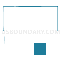
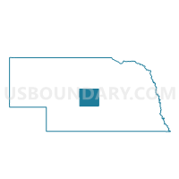
Outline

Summary
| Unique Area Identifier | 612654 |
| Name | Loup Precinct |
| County | Custer County |
| State | Nebraska |
| Area (square miles) | 143.08 |
| Land Area (square miles) | 143.05 |
| Water Area (square miles) | 0.04 |
| % of Land Area | 99.97 |
| % of Water Area | 0.03 |
| Latitude of the Internal Point | 41.14098730 |
| Longtitude of the Internal Point | -99.54998760 |
Maps

Graphs
Select a template below for downloading or customizing gragh for Loup Precinct, Custer County, Nebraska


Neighbors
Neighoring Voting District (by Name) Neighboring Voting District on the Map
- Algernan Precinct, Custer County, NE
- Ansley Precinct, Custer County, NE
- Berwyn Precinct, Custer County, NE
- East Center Precinct, Custer County, NE
- Elk Creek Precinct, Custer County, NE
- Kennebec Precinct, Dawson County, NE
- Wood River Precinct, Custer County, NE
- Woodriver Precinct, Dawson County, NE
Top 10 Neighboring County Subdivision (by Population) Neighboring County Subdivision on the Map
- Ansley township, Custer County, NE (599)
- Wood River precinct, Dawson County, NE (459)
- Wood River township, Custer County, NE (326)
- Algernon township, Custer County, NE (305)
- Berwyn township, Custer County, NE (232)
- Kennebec precinct, Dawson County, NE (183)
- Loup township, Custer County, NE (129)
- Elk Creek township, Custer County, NE (126)
- East Custer township, Custer County, NE (47)
Top 10 Neighboring Unified School District (by Population) Neighboring Unified School District on the Map
- Broken Bow Public Schools, NE (4,934)
- Callaway Public Schools, NE (1,294)
- Ansley Public Schools, NE (1,048)
- Sumner-Eddyville-Miller Schools, NE (947)
Top 10 Neighboring State Legislative District Upper Chamber (by Population) Neighboring State Legislative District Upper Chamber on the Map
Top 10 Neighboring 111th Congressional District (by Population) Neighboring 111th Congressional District on the Map
Top 10 Neighboring Census Tract (by Population) Neighboring Census Tract on the Map
- Census Tract 9718, Custer County, NE (2,827)
- Census Tract 9680, Dawson County, NE (2,584)
- Census Tract 9720, Custer County, NE (1,442)